


Which is your city’s least climate-proof neighborhood?
You’d think it would be the low-lying oceanfront areas!
Not according to the Social Vulnerability Index.
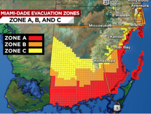
As Hurricane Irma approaches, our news is filled with maps – wind speed, storm surge, flooding, evacuation priorities (at left) – all which define an endangered area or a climate-proof neighborhood. Based on its flat land, oceanfront position, property values, and frequent flooding, Miami Beach would seem to be the riskiest area in Irma’s path.
But if you look beyond the video clips of waves crashing and apartment towers swaying, you’ll see different vulnerabilities. Take one example. Miami Beach residents may be able to afford a trip to Georgia, New York, or Bogotá, but many Miami residents don’t have the funds or the vehicles to evacuate.
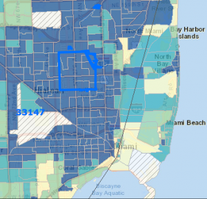
A different map (at right) takes into account this immobility and other factors such as poverty, crowded housing, and poor planning that boost financial loss. It’s from the Center for Disease Control, and they call it the Social Vulnerability Index. You can find the SVI for your hometown or any other Zip Code in America.
The SVI of Miami Beach is above average – but not in the Top Quartile! The poorer blocks back from the ocean are the most vulnerable. Residents are likely to have less food, water, emergency power, or medicine. They may get slower service from emergency personnel or fewer emergency shelters. The elderly, those with no vehicles, or those who don’t understand English well are less likely to get help evacuating or protecting their property.
Failure to protect these people, slow repair of their properties and businesses, and inadequate health services after the disaster pile up big, long-term costs. Most people are surprised to learn that a city’s costs from social vulnerability can exceed its costs from physical damage. By contrast, good plans and stockpiled resources to reduce social costs can be much cheaper than what’s needed to prevent physical damage. Boston, MA understands this. Check out that city’s Climate Vulnerability Assessment.
Many will be thinking as we watch the hurricane images this weekend, “How can I help protect my own community from the next hurricane – or drought, or forest fire, or other threat from climate change.” If you just want to reduce property damage, it’s natural to focus on protecting exposed, high-priced buildings and infrastructure. But if you want to create a more climate-proof neighborhood overall and reduce the size and duration of economic loss in your community, you should urge your officials to go for the biggest savings – by reducing the social costs. Your town won’t just be showing compassion, they’ll be creating a low-cost economic benefit for the whole community.
And looking further ahead, if the disaster in southern Florida has got you wondering about where you could live more safely in the future, check out our Where-To-Live Scorecards. They incorporate the Social Vulnerability Index, along with many other indicators of a climate-proof neighborhood.